

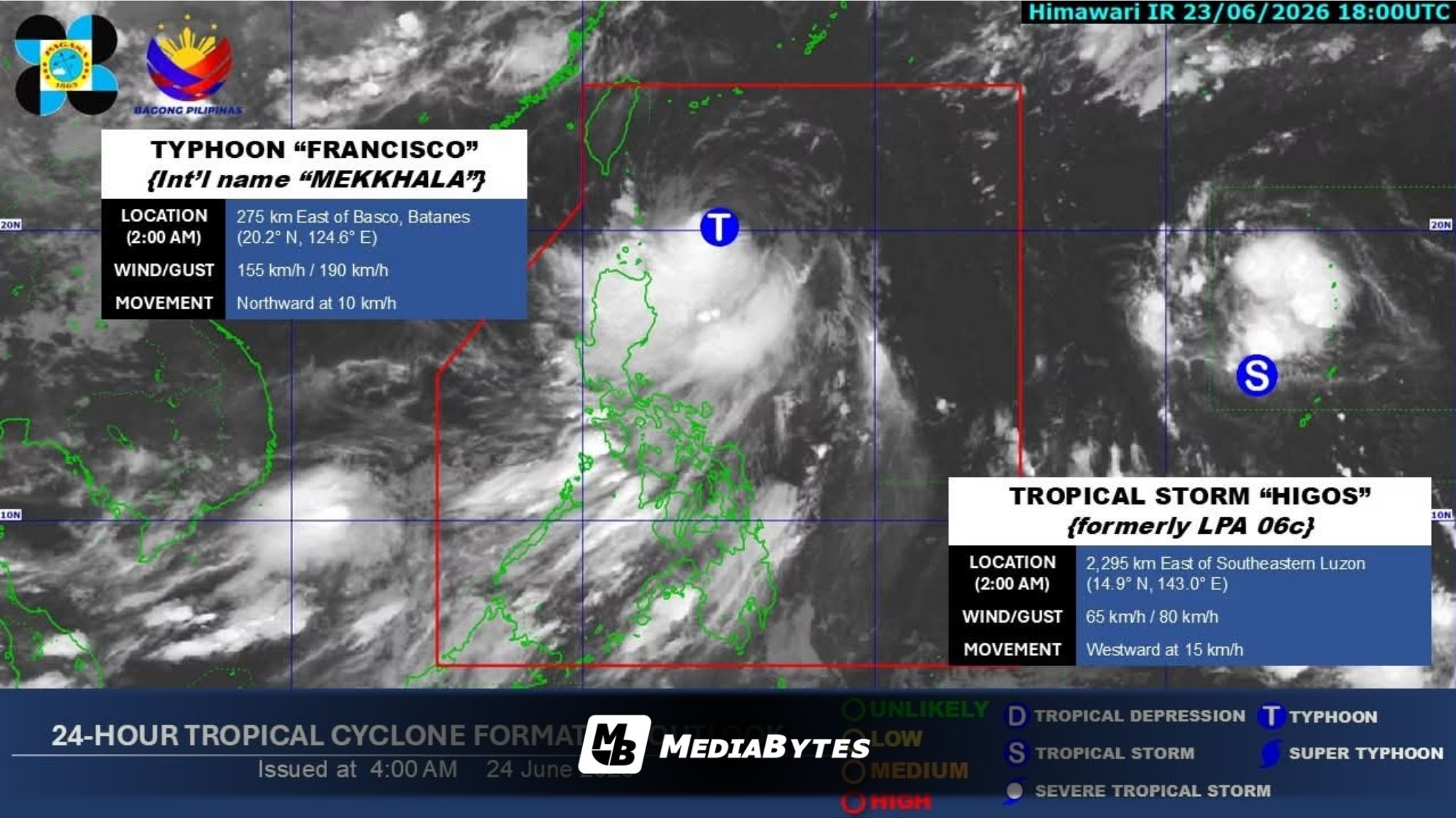
Typhoon Francisco has begun losing strength as it moves northward over the Philippine Sea, but state weather bureau PAGASA has maintained Tropical Cyclone Wind Signal No. 1 over Batanes and parts of northeastern Cagayan.
According to the 5 a.m. weather bulletin on Wednesday, June 24, the storm’s center was spotted around 4 a.m. about 275 kilometers east of Basco, Batanes, carrying maximum sustained winds of 155 kilometers per hour and gusts reaching up to 190 kph.
The weather bureau noted that Signal No. 1 remains active for Batanes, the Babuyan Islands, and the northeastern section of mainland Cagayan—specifically covering Santa Ana and Gonzaga.
Residents in these locations have been cautioned to prepare for minimal to minor disruptions caused by strong winds.
Even as it slows down, Francisco is still intensifying the southwest monsoon, locally known as habagat.
This interaction is triggering strong to gale-force winds across massive chunks of Luzon and the Visayas, reaching down into Mindanao provinces like Dinagat Islands, Davao Occidental, Davao Oriental, Camiguin, Lanao del Norte, and Misamis Occidental.
A Gale Warning is currently active for the northern and eastern coastlines of Northern Luzon. Sea travel is highly dangerous, with wave heights projected to reach 4.5 meters along the eastern shores of Batanes, the Babuyan Islands, and northeastern mainland Cagayan.
Maritime authorities have advised operators of all types of vessels to remain at port or seek safe harbor.
Small watercraft have also been warned against navigating waters surrounding Cagayan, Batanes, and the Babuyan Islands, where waves could swell to 3.5 meters.
PAGASA noted that while the typhoon is projected to steer clear of making direct landfall on the Philippine mainland, its pull on the monsoon means heavy rains, rough waters, and strong winds will still impact areas well away from the storm’s direct path.
Francisco is forecast to maintain a northward track until Thursday morning, after which it will shift north-northeast toward southern Japan and the Ryukyu Islands.
The typhoon is expected to exit the Philippine Area of Responsibility (PAR) between Thursday night and early Friday morning.